


GARMIN
Garmin Aera 660 Touchscreen Portable GPS
Part No: 010-01518-00
$899.00
/
Shipping calculated at checkout.
DESCRIPTION
Garmin Aera 660 Touchscreen Portable GPS
The Garmin Aera 660 is one of the most popular, cost-effective, and feature-rich purpose-built garmin gps for aviation. It doesn't hurt that it is also portable to take anywhere on the go!
Garmin Aera 660 For Sale
The compact 5-inch capacitive touchscreen boasts a bright, sunlight-readable display complete with rich, interactive maps and a built-in GPS/GLONASS receiver that can be viewed in portrait or landscape modes for optimum customization. The Garmin Aera 660 GPS encompasses many of the features of the renowned Aera and GPSMAP aviation portable series, adding new Connext wireless capabilities, Garmin WireAware wire-strike avoidance technology, and more.
Garmin Aviation Portable GPS Display Features
New cost-effective database options and built-in Wi-Fi database updating capabilities allow customers to more easily access the most up-to-date data, including daily U.S. fuel prices. Bluetooth supports the display of ADS-B "In" traffic and weather from various sources, including the GDL 39/GDL 39 3D, Flight Stream, and the GTX 345 ADS-B transponder.
Garmin Aera 660 Recommended Panel & Yoke Docks (Not Included)
We recommend this mount for those looking to hide wires on long flights:
Other Optional Powering Dock Compatible with Flight Yokes:
Bare Wired Dock Compatible with Flight Yokes:
Advanced Capabilities in a Portable GPS Package
- Rugged, purpose-built portable navigator with built-in GPS/GLONASS receiver and 5-inch sunlight-readable screen
- Intuitive, simple touchscreen operation and single power button make getting around the display a cinch
- 3D Vision perspective view shows terrain, obstacles, airport environment, optional traffic, nearest airport, and more
- Wireless cockpit connectivity via Connext® streams weather and traffic from compatible devices
- Cut the cord and database prices with Wi-Fi® database downloads and the affordable Garmin Navigation Database
Garmin 660
The aera 660 airplane GPS puts the latest Garmin technology in the palm of your hand, and it carries on our tradition of creating innovative navigators that go way back to the beginning of handheld aviation GPS. While aera 660 is light, compact, and fits in any flight bag, it's also packed with capabilities. As a dedicated navigator, it quickly and reliably acquires GPS and GLONASS satellite constellations and combines advanced navigation tools with rich, interactive, dynamically drawn aviation maps. And it displays it all on a bright, sunlight-readable 5-inch diagonal capacitive touchscreen display.
The icons on the aera 660 are instantly familiarƒ to anyone who's used a Garmin GTN™ touchscreen GPS/NAV/COMM, G5000® integrated flight deck, or even the Garmin Pilot™ app, and the intuitive interface allows you to quickly pan across the map screen, pinch to zoom and more. Meanwhile, the power button on the top accesses quick settings, including portrait or landscape orientation, volume, and brightness.

Complete Flight Mapping
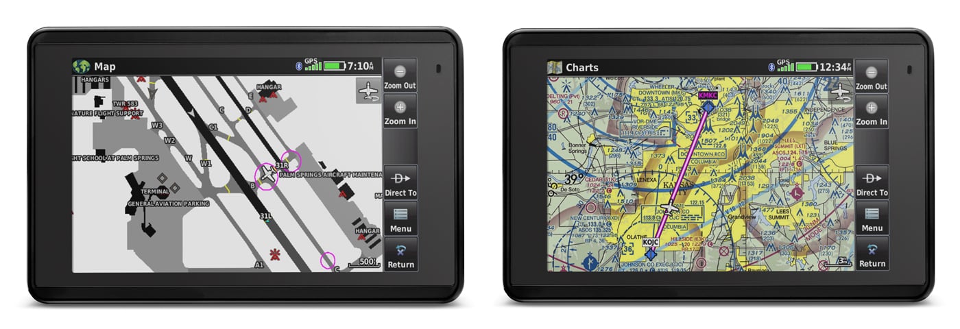
The aera 660 aviation portable comes preloaded with detailed flight mapping, terrain and obstacles alerting, U.S., European, and Canadian SafeTaxi® charts, and AOPA Airport Directory optional AC-U-KWIK global airport directory to put a wealth of resources right at your fingertips — including local fuel prices (U.S. only). The graphical Terrain page offers overhead and vertical profile views of the topography beneath you. Switch to IFR map mode to display and navigate on high or low enroute airways, and use your touchscreen map cursor to reference MEAs (Minimum Enroute Altitudes) and distances between intersections. The aera 660 even provides vertical navigation (VNAV) guidance to simplify en-route transitions.
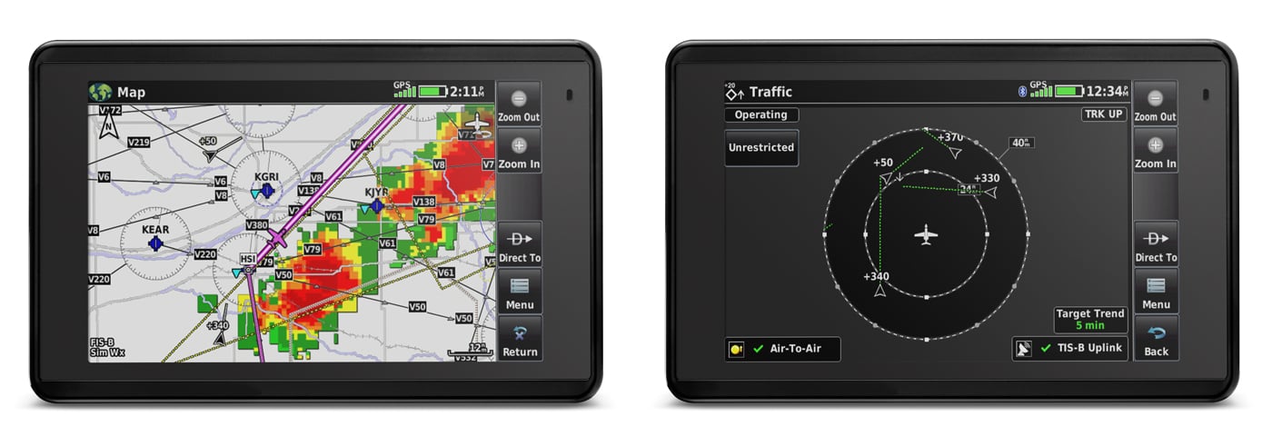
You'll stay aware of particular airspace activity with more than 650 parachute drop zone details (U.S. only) and get 1-touch airspace information. Garmin Smart Airspace™ guidance conveniently highlights the airspace nearest your current altitude and de-emphasizes non-pertinent airspace so you can quickly identify your location relative to the airspace around you. And, of course, the aera 660 includes our signature direct-to and nearest-airport navigation.
Connect With Your Panel
With an optional power/data cable (sold separately), the aera 660 connects with your Garmin avionics to accept flight plans from your GTN 750/650 navigators, as well as upload frequencies to the standby position of your GTR 200 Comm radio, GTR 225 Comm radio or GNC 255 NAV/COMM radio. It also provides your Garmin NAV/COMM radios with the GPS position source required to look up the nearest frequencies. Check out more Garmin aircraft gps solutions.
Weather and Traffic Without Wires
Using Bluetooth® connectivity via Garmin Connect technology, the aera 660 easily interfaces with compatible devices to cut the clutter in your cockpit and improve your flying experience. With a Garmin GDL® 52 portable ADS-B/SiriusXM® receiver or GTX 345 all-in-one ADS-B transponder, you can access and display ADS-B subscription-free weather¹ and advanced traffic alerts, including TargetTrendTM relative motion tracking and TerminalTrafficTM, so you're aware of potential conflicts in busy terminal airspace. It even allows wireless control of Garmin VIRB® action cameras to start and stop recording and capturing photos.
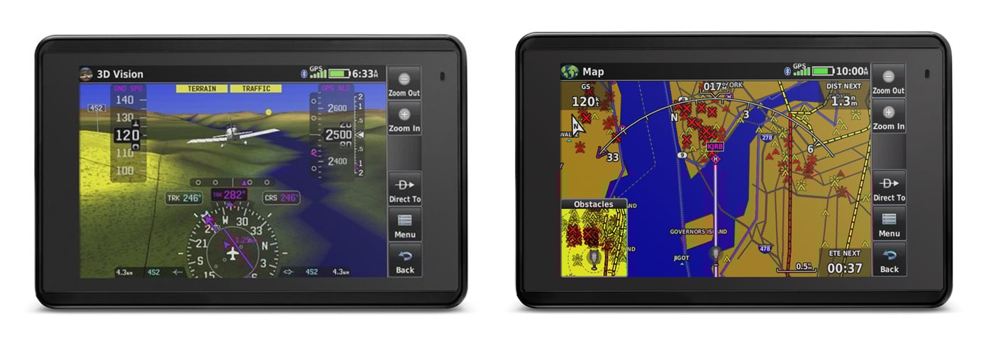
GPS Receiver with 3D Vision Technology
Revolutionary 3D Vision technology gives you a virtual 3-D behind-the-aircraft perspective view of surrounding terrain derived from GPS/GLONASS and the onboard terrain database. Slide your finger across the touchscreen to rotate the view and show land and water features, obstacles, runways, and airport signposts relative to the aircraft. And when you connect aera 660 to an attitude source through a Flight Stream 210 or Flight Stream 510, a GDL 52 series portable data link, or a GTX 345 ADS-B transponder, Garmin SVX synthetic vision and attitude command bars are automatically added to your display.
Plus, with its forward-looking terrain avoidance capability, the aera 660 predicts in advance where towers or obstacles may exist and shades the landscape with amber or red overlays to indicate those areas. Also, get help flying clear of conflicts with Garmin WireAware™ wire-strike avoidance technology, which graphically overlays Hazardous Obstacle Transmission (HOT) lines that span rivers and canyons right on the moving map page for the U.S. as well as in some locations in both Canada and Mexico. Touch the wire to display both MSL and AGL heights, and see color-coded obstacle alerting depending on your distance to the hazard. An optional complete database that includes all powerlines is also available.
Stay Up to Date With Garmin
With the aera 660, you can cut the cord — and your database prices. You can update databases via Wi-Fi instead of connecting to a computer and stay current throughout the year with a single, affordable annual subscription that includes all the databases you need, including the Garmin Navigation Database (U.S., Canada, Mexico-version only).
All-in-one Functionality
The aera 660 fulfills the role of either a Class I or Class II electronic flight bag, significantly reducing the need to rely on paper charts in the cockpit. U.S. geo-referenced VFR sectional and IFR enroute charts come preloaded to show your aircraft's position overlaid directly on the relevant chart, and optional European and Canadian VFR and IFR charts and airport diagrams are also available.
In IFR map mode, the aera 660 can display victor airways, jet routes, leg distance, and more, similar to traditional enroute charts. Plus, pilots who prefer Jeppesen charts and diagrams can use built-in ChartView capability, which uses Jeppesen's extensive library to provide global geo-referenced charting capabilities. European users receive European VFR Map enhancements to see more visual reference points, including borders, lakes, roads, grasslands, parks, and more.
Aera 660 Home Dock
Designed to securely hold your aera 660 for desktop use in your home, office, or FBO pilot lounge, this sturdy metal mounting stand works with the USB and power adapter cables provided with your portable navigator – allowing you to to keep your unit charged while positioning the aera's touchscreen so you can use it to set up flight plans, review airport information, and perform other critical preflight planning tasks, comfortably and conveniently.
In a Class by Itself
With its long list of features, the aera 660 combines many of the capabilities of panel-mounted avionics with a value-packed, purpose-built package. It's a dedicated partner that's ready to fly right out of the box.
¹ Limited to coverage in the U.S.
Wi-Fi is a registered trademark of the Wi-Fi Alliance. Bluetooth is owned by Bluetooth SIG, Inc.
Pair With ADS-B, Traffic, & Weather ADS-B traffic and weather1 can be transferred via the wired connection to the Garmin Aera 660 when linked to the GTX 345, GDL 39, or GDL 39 3D.
The Garmin Aera 760 is also available! Ready to upgrade to a Garmin Avionics GPS?
Looking for more solutions? Explore our avionics gps collection.
Features
- Rugged, purpose-built portable navigator
- Built-in GPS/GLONASS receiver
- 5-inch sunlight-readable screen
- Intuitive, simple touchscreen operation
- Single power button make getting around the display a cinch
- 3D Vision perspective view shows terrain, obstacles, airport environment, optional traffic, nearest airport and more
- 3D Vision also displays lateral and vertical (VNAV) deviation bars and includes a 360-degree HSI
- Wireless cockpit connectivity via Connext® streams ADS-B weather and advanced traffic from compatible devices
- Wi-Fi® database downloads
- Affordable Garmin Navigation Database
- Optimized for cockpits and various types of flying
- Mini-USB connector, microSD card slot and removable battery
- Depending on settings & connections, pilots will receive up to 4-6 hours of battery life on a single charge
- Interface resembles the GTN 650/750 touchscreen series
- Comprehensive chart options provide pilots with an easy path to a paperless cockpit
- Built in features tailored to helicopter operators, including Garmin WireAware & standard obstacle database contains Hazardous Obstacle Transmission (HOT) lines
- Standard included accessories:
- Yoke mount with power cable
- Battery
- AC adapter
- USB cable
- Quick start manual & documentation
- Includes:
- 3D Vision
- Wireless Database Updating
- Garmin WireAware
- Connext
- TargetTrend (when paired with compatible devices)
- TerminalTraffic (when paired with compatible devices)
- Smart Airspace
- Preloaded Garmin FliteCharts
- Animated NEXRAD (when paired with compatible devices)
- SafeTaxi
- Fuel Prices
- VIRB XE Control
Specifications
Physical & Performance
- Physical dimensions: 5.5”W x 3.4”H x .8”D (14.1 x 8.7x 2.1 cm)
- Display size, WxH: 4.35"W x 2.61"H (11.1 x 6.6 cm); 5.08" diag (12.9cm)
- Display resolution, WxH: 480 x 800; portrait and landscape orientation
- Display type: touchscreen WVGA color TFT with white backlight
- Weight: 8.64 ounces (245 g) with battery; 7.23 ounces (205 g) without battery
- Battery: removable, rechargeable lithium-ion
- Battery life: Up to 4 hours during most daytime conditions, (80% backlight) and wireless connectivity in the cockpit, e.g. GTX 345; up to 6 hours during typical nighttime conditions, (5% backlight) and without wireless connectivity.
- SBAS/WAAS/GLONASS receiver: high-sensitivity with WAAS position accuracy
- Voltage range: 10-35
- IFR or VFR: VFR
- Traffic Information Services (TIS) alerts compatible: yes
- Accepts data cards: yes (microSD™ cards)
Why Gulf Coast Avionics?
Gulf Coast Avionics is a leading supplier of avionics, pilot supplies and aircraft services.
Since 1984 Gulf Coast Avionics has been providing quality merchandise from name brand manufacturers to keep pilots, aircraft owners and operators flying.
Questions? Call us Toll Free:
800.474.9714
Our E-commerce Website and our annual Product Catalog are favorites among aviators around the world. With a comprehensive inventory developed to meet almost any avionics, instrument, or pilot supply need, you're sure to find what you want. You will find our prices unbeatable. We guarantee them to be the lowest in the industry!
Our experienced, factory-trained technicians deliver precision avionics installations designed for performance, safety, and reliability. As an FAA Approved Repair Station, we complete certified upgrades and full panel integrations for a wide range of aircraft, from general aviation singles and twins to corporate aircraft, warbirds, and helicopters, bringing the same level of craftsmanship and attention to detail to every project.